A web-based maritime situational awareness tool
Overview
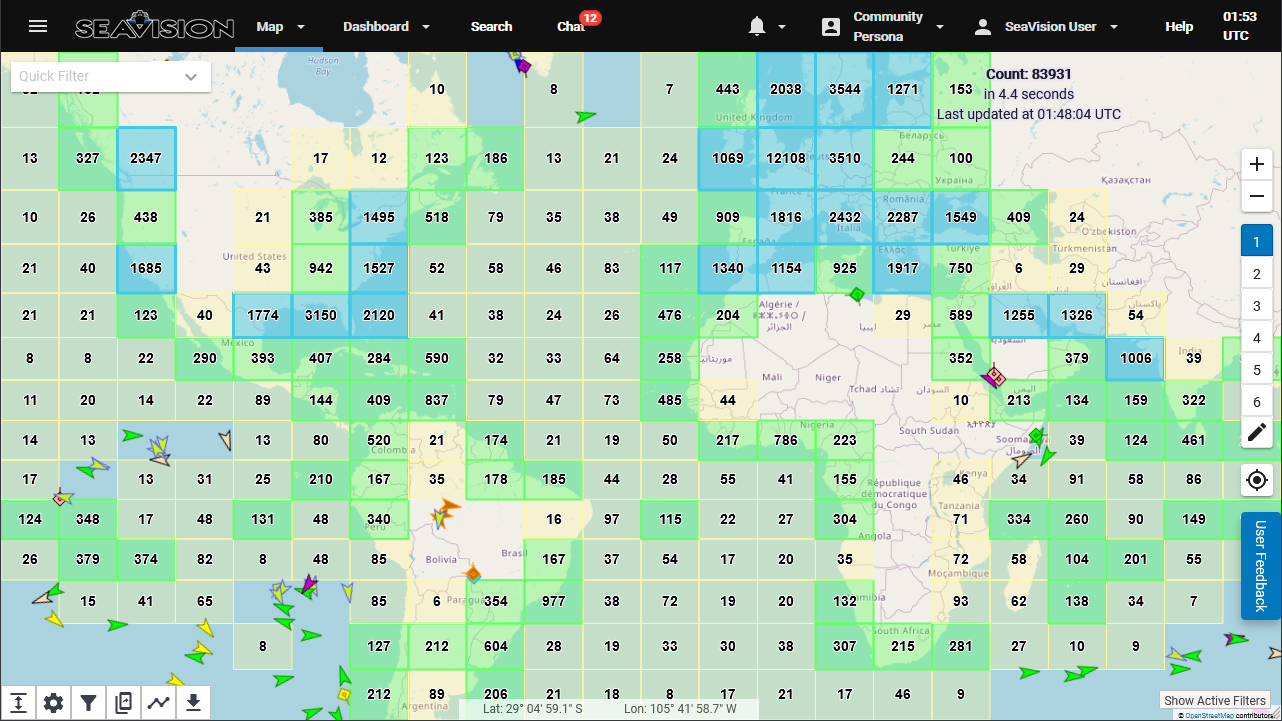
SeaVision is a web-based maritime situational awareness tool that enables users to view and share a broad array of maritime information to improve maritime operations, increase maritime security, and build partnerships within the maritime community.
To assist the user in managing the information, SeaVision provides user-defined rules-based analytics to evaluate and notify the user of defined maritime activities or events. SeaVision is a low-cost visualization and management tool that has the ability to quickly add and correlate multiple data sources to meet various mission needs.
Features
View and track position and movement information for tens of thousands of ships around the world
Use advanced filtering and search capabilities to query large amounts of data
Define automated queries and rules to highlight anomalies and generate alerts
Share searches, rules, alerts, shapes and vessel lists with other users within Communities and Personas
Data

Automatic Identification System (AIS)
SeaVision includes AIS data from various sources, displayed in real time via the SeaVision map. AIS data services deliver a global picture of vessel activity including information about individual vessels.
Satellite Synthetic Aperture Radar (SAT-SAR)
SeaVision displays vessel position data derived from satellite radar imagery and has the ability to correlate this data with AIS position reports.

Maritime Safety and Security Information System (MSSIS)
SeaVision ingests vessel data from MSSIS, a near-real-time data collection and distribution network where international participants share AIS position reports.

Visible Infrared Imaging Radiometer Suite (VIIRS)
SeaVision displays vessel position data derived from the satellite detection of man-made light sources emanating from ships, and other man-made sources at sea.

Coastal Radar
SeaVision can display vessel radar detections sourced from a SeaVision participant nation’s shore-based sea radar network. These detections can also be correlated with AIS position reports for individual vessels.
Electro-Optical Imagery
SeaVision can provide high-resolution images of vessels along with position and heading information sourced from electro-optical satellite data. This data can also be correlated with AIS position reports.

Radio Frequency (RF)
SeaVision includes radio frequency data from our commercial partner that is collected by satellite and analyzed to identify the type and location of radio emissions. This data can be correlated with AIS position reports or can assist with detecting and tracking vessels that are not emitting AIS signals.

Event Monitoring
SeaVision can indicate vessel rendezvous and unusual vessel activity using algorithmically generated intelligence from third-party providers.

Ship Registry Data
SeaVision integrates ship registry data with incoming position reports to provide extensive vessel information to the user. The data is searchable and used as criteria for several tools in SeaVision.
Weather
SeaVision provides an array of historical, current, and forecasted weather data. Coverage is worldwide, and includes wind speed and direction, precipitation, temperature, and more.
Communities and Personas
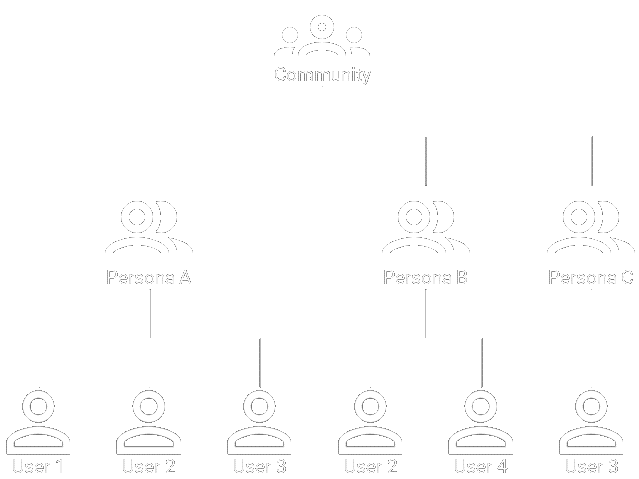
Users and information are managed through Communities and Personas. Communities are groups of users with a shared mission and are overseen by a Community Manager. A Persona is a focused sub-group within a Community. Personas are created by the Community Manager who assigns users to the appropriate Persona within the Community. Access to a Persona grants access to authorized data and shared objects.
Users

SeaVision has over 5,000 active users from 120 partner nations.
SeaVision Team